Файл:1796 Mannert Map of North America and South America - Geographicus - America-mannert-1796.jpg
Перейти к навигации
Перейти к поиску

Размер этого предпросмотра: 690 × 599 пкс. Другие разрешения: 276 × 240 пкс | 553 × 480 пкс | 884 × 768 пкс | 1179 × 1024 пкс | 2358 × 2048 пкс | 5000 × 4343 пкс.
Исходный файл (5000 × 4343 пкс, размер файла: 5,75 МБ, MIME-тип: image/jpeg)
Этот файл находится на Викискладе. Сведения о нём показаны ниже.
Викисклад — централизованное хранилище для свободных файлов, используемых в проектах Викимедиа.
|
| America nach der zweyten Ausgabe von Arrowsmiths Weltcharte und dessen Globular Projection nach den Berichten der Jesuiten und anderer Reisebe Schreiber, und nach Raymals, Gatterers, Angaben entworten von C. Mannert. | ||||||
|---|---|---|---|---|---|---|
| Автор | ||||||
| Название |
America nach der zweyten Ausgabe von Arrowsmiths Weltcharte und dessen Globular Projection nach den Berichten der Jesuiten und anderer Reisebe Schreiber, und nach Raymals, Gatterers, Angaben entworten von C. Mannert. |
|||||
| Описание |
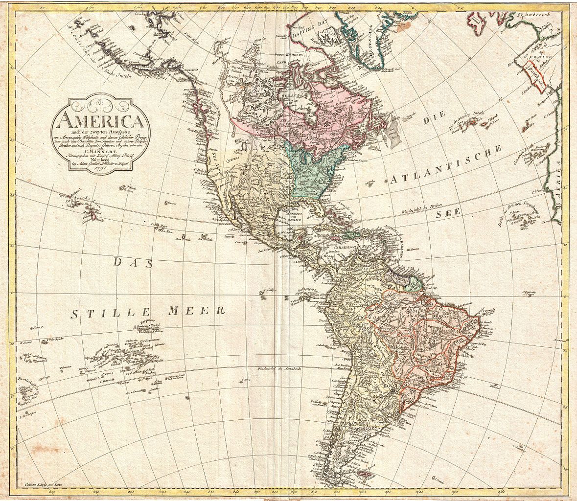
English: An extremely scarce 1796 map of north and south America by C. Mannert. Depicts the Americas shortly following the close of the American Revolutionary War in 1783. The whole is color coded according to political conventions, with British controlled territories in Red, Spanish dominions in yellow, French in green, and the fledgling United States in blue-green. Mountains and other topographical features are rendered by hachure, making Mannert's 1796 map one of the first to employ this mapping convention. Throughout, Mannert has dedicated significant attention to the naming of various American Indian nations including the Sioux, Otter, Sack, Creek (Crik), Miami, Paduca, Arkansas, and others. Cartographically Mannert references the work of Aaron Arrowsmith published in the same year, though it is far from a copy with numerous refinements and advancements in evidence. Mannert recognizes the United States east of the Mississippi, south of the Great Lakes, and north of Florida. None of the original states are identified, however the regions of Carolina, Georgia, and Kentuke are noted. This map's most interesting element is most likely it's treatment of the western parts of North America. At the extreme west the discoveries of Captain Cook are evident in the well defined coastlines as far north as Alaska. Here the Bering Strait has been renamed Cook's Strasse. Drakes harbor, the mysterious location where Sir Frances Drake repaired his ships (and claimed New Albion for England) on his historic circumnavigation, is here identified with San Francisco Bay. Further inland the cartography becomes increasingly vague with places like Teguayo, Quivara, and Cenis (all remnants early ingressions into this region by the likes of Coronado and de Soto) appearing throughout. Teguayo, a semi-mythical kingdom of gold and wealth imagined by the nefarious Spanish count and governor of New Mexico Pansilo de Navarez, is attached to an embryonic Great Salt Lake - no doubt drawn and adapted from Escalante's journals. Further north, near today's U.S. - Canada border another lake appears - this one much larger and labeled See. This unusual body of water is most likely a remnant of the mythical Sea of the West, a speculative lake proposed by 18th century French theoretical cartographers. Further north still we can see traces of the exploratory work of MacKenzie and Hearne, both fur traders whose overland treks in northwestern Canada along the MacKenzie and Coppermine Rivers, respectively, finally ended speculation about a river passage to the Pacific via the Hudson Bay. At the opposite extreme of this map South America appears well mapped with significant inland detail throughout. However, though based upon missionary reports and mapping conventions dating to the time of the Conquistadores, much of this cartography is speculative at best. Unlike North America, much of the South American coastline was mapped early on in the history of American exploration. However, the interior was vague and confusing to cartographers who had difficulty embracing the complexities of mapping the continent's impenetrable rainforests, great flood plains, and vast winding river systems. Nonetheless, many confusions appearing on earlier (and indeed later) maps have here been semi-corrected. Both Lake Parima (south Guyana) and the Laguna de Xarayes (northern terminus of the Paraguay River) have been significantly reduced in size. These were flood plains, the Parima and Pantanal, that were mistakenly taken for lakes during their annual inundation and both of which were associated with legends of El Dorado. All text is in German. Prepared on a scale of 1:20,000,000. Drawn by Conrad Mannert for the publication by the Nurenburg firm of Adam Gottlieb Schneider and Weigel. |
|||||
| Дата | 1796 (dated) | |||||
| Размеры | высота: 21 дюймов (53,3 см); ширина: 24 дюймов (60,9 см) | |||||
| Инвентарный номер |
Geographicus link: America-mannert-1796 |
|||||
| Источник/Фотограф |
|
|||||
| Права (Повторное использование этого файла) |
|
|||||
История файла
Нажмите на дату/время, чтобы посмотреть файл, который был загружен в тот момент.
| Дата/время | Миниатюра | Размеры | Участник | Примечание | |
|---|---|---|---|---|---|
| текущий | 11:21, 24 марта 2011 | | 5000 × 4343 (5,75 МБ) | BotMultichillT | {{subst:User:Multichill/Geographicus |link=http://www.geographicus.com/P/AntiqueMap/America-mannert-1796 |product_name=1796 Mannert Map of North America and South America |map_title= America nach der zweyten Ausgabe von Arrowsmiths Weltcharte und dessen G |
Использование файла
Следующие 73 страницы используют этот файл:
- Маннерт, Конрад
- Участник:AQVA121/Награды
- Участник:Aisford
- Участник:Bumın qahan
- Участник:DS28
- Участник:Kalisidina
- Участник:Kalisidina/Черновик-2/Архив/1
- Участник:Khan Zamay
- Участница:Lvova
- Участница:Lvova/Награды
- Участник:MasterRus21thCentury/Награды
- Участник:Oleg4280
- Участник:Talgautb
- Участник:VAP+VYK/Награждения
- Обсуждение участника:AQVA121/Архив/2020
- Обсуждение участника:Adavyd
- Обсуждение участника:Aisford
- Обсуждение участника:Alex Alex Lep
- Обсуждение участника:Alex parker 1979/Архив/1
- Обсуждение участницы:Alicamyrt/Архив
- Обсуждение участника:Amarhgil
- Обсуждение участника:Balabinrm
- Обсуждение участника:Brateevsky/Архив/14
- Обсуждение участника:Bumın qahan
- Обсуждение участника:CesarNS1980/Архив/2023
- Обсуждение участника:DS28/Архив/2020/1
- Обсуждение участника:Darkhan/Архив/1
- Обсуждение участника:Deinocheirus/Архив/15
- Обсуждение участника:Egilus
- Обсуждение участника:Elektro01
- Обсуждение участника:Geoladys
- Обсуждение участника:JukoFF/2020 год
- Обсуждение участника:Kalisidina/Архив-2020 - март 2021
- Обсуждение участника:Kalisidina/Архив/1
- Обсуждение участника:Khan Zamay/Архив/2020
- Обсуждение участника:Lockenhart
- Обсуждение участника:Luckyloser77
- Обсуждение участницы:Lvova/Архив/35
- Обсуждение участника:MasterRus21thCentury/Архив/2
- Обсуждение участника:Mitte27/Архив/7
- Обсуждение участника:Oleg4280/Архив/2021
- Обсуждение участника:Ostrovsky Gregory
- Обсуждение участника:Pauk
- Обсуждение участника:Pticy uleteli/Архив
- Обсуждение участника:Redfog
- Обсуждение участника:Redfog/Архив/2021
- Обсуждение участника:Sentinel R/Архив-2020
- Обсуждение участника:Sentinel R/Архив-2021
- Обсуждение участника:Sentinel R/Архив-2022
- Обсуждение участника:Softy/Архив/2020
- Обсуждение участника:Talgautb/Архив/2020
- Обсуждение участника:ThomasFrolov
- Обсуждение участника:VAP+VYK/Архив 2020-05
- Обсуждение участника:Winterpool
- Обсуждение участника:Андрей Бондарь
- Обсуждение участника:Джекалоп/Архив/10
- Обсуждение участника:Джекалоп/Архив/11
- Обсуждение участника:Иван Богданов/Архив/2
- Обсуждение участника:Иван Богданов/Архив/3
- Обсуждение участника:Камарад Че
- Обсуждение участника:Карго Вейксе
- Обсуждение участника:Мистер Х
- Обсуждение участника:Рогволод/Архив/1
- Обсуждение участника:Филипп Лысанов
- Обсуждение участника:ШаманСемен/Архив/1
- Обсуждение участника:ШаманСемен/Архив/Jul2020-Jun2022
- Обсуждение участника:ШаманСемен/Архив/Jul2022-2023
- Обсуждение участника:Шаманн
- Проект:Тематическая неделя американских регионов/Восьмая Общеамериканская неделя
- Проект:Тематическая неделя американских регионов/Девятая Общеамериканская неделя
- Проект:Тематическая неделя американских регионов/Седьмая Общеамериканская неделя
- Проект:Тематическая неделя американских регионов/Шестая Общеамериканская неделя
- Проект:Тематическая неделя американских регионов/Юбилейный американский месячник
Глобальное использование файла
Данный файл используется в следующих вики:
- Использование в de.wikipedia.org