Файл:Marius hills pit.png
Перейти к навигации
Перейти к поиску

Размер этого предпросмотра: 800 × 508 пкс. Другие разрешения: 320 × 203 пкс | 640 × 406 пкс | 1024 × 650 пкс | 1430 × 908 пкс.
Исходный файл (1430 × 908 пкс, размер файла: 746 КБ, MIME-тип: image/png)
Этот файл находится на Викискладе. Сведения о нём показаны ниже.
Викисклад — централизованное хранилище для свободных файлов, используемых в проектах Викимедиа.
|
Краткое описание
| Описание |
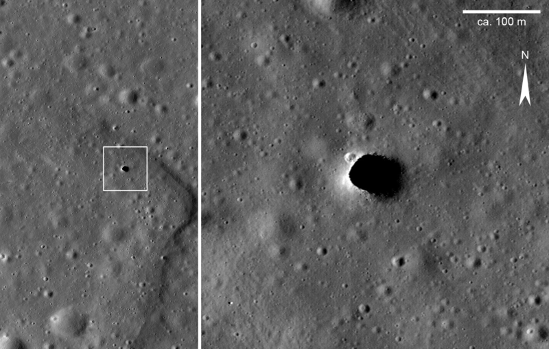
English: Photograph of a ‘hole’ in the Moon’s surface in the Marius Hills area, Oceanus Procellarum, taken by the Lunar Reconnaissance Orbiter probe (LRO). The right image renders a magnification of the area which is enclosed in the white box in the left image. In the left image the situation of the ‘hole’ within a shallow, sinuous rille structure (rima) is well recognizable. Because rilles are thought to represent fossil lava streams, the ‘hole’ is interpreted as a skylight of a lava tube (cf. Haruyama et al., 2009[1]). The Marius Hill hole is the first such feature ever spotted on Moon. The scale bar is according to the image being about 900 pixels wide with a pixel covering about 0.5×0.5 m of the Moon’s surface. Deutsch: Foto eines ‚Lochs‘ in der Oberfläche des Mondes in der Marius-Hills-Region, Oceanus Procellarum, aufgenommen von der Lunar-Reconnaissance-Orbiter-Sonde (LRO). Das rechte Bild ist eine Vergrößerung der im linken Bild weiß eingekästelten Region. Im linken Bild ist die Lage des ‚Lochs‘ in einer flachen, gewundenen Mondrille (Rima) gut erkennbar. Weil Mondrillen als fossile Lavaflüsse gelten, wird das ‚Loch‘ als sogenanntes Skylight, die partiell eingestürzte Decke einer Lavaröhre, interpretiert (vgl. Haruyama et al., 2009[1]). Das ‚Loch‘ in den Marius Hills ist die erste derartige Struktur, die je auf dem Mond entdeckt wurde. Der Maßstabsbalken richtet sich danach, dass das Bild rund 900 Pixel breit ist, wobei ein Pixel etwa 0,5×0,5 m Mondoberfläche abdeckt.
|
| Дата | |
| Источник | Extracted and modified from CDR PTIF file downloaded at LROC Data Node of the NASA Planetary Data System; URL to download page is http://wms.lroc.asu.edu/lroc/view_lroc/LRO-L-LROC-2-EDR-V1.0/M114328462RE |
| Автор | NASA/Lunar Reconnaissance Orbiter Camera (LROC) Science Operations Center (SOC) team at Arizona State University |
Лицензирование
| Этот файл находится в общественном достоянии (англ. public domain), так как он был создан NASA (Национальным управлением по аэронавтике и исследованию космического пространства). Политика авторского права NASA гласит, что «Материал NASA не защищается авторским правом, если не указано иное». (См. Template:PD-USGov, страницу политики авторского права NASA или политику использования изображений JPL.) | ||
 |
Предупреждения:
|
История файла
Нажмите на дату/время, чтобы посмотреть файл, который был загружен в тот момент.
| Дата/время | Миниатюра | Размеры | Участник | Примечание | |
|---|---|---|---|---|---|
| текущий | 22:28, 1 ноября 2018 | | 1430 × 908 (746 КБ) | Gretarsson | {{Information |description ={{en|1=Photograph of a ‘hole’ in the Moon’s surface in the Marius Hills area, Oceanus Procellarum, taken by the Lunar Reconnaissance Orbiter probe (LROC). The right image renders a magnification of the area which is enclosed in the white box in the left image. In the left image the situation of the ‘hole’ within a shallow, sinous rille structure (rima) is well recognizable. Because rilles are thought to represent fossil lava streams, the ‘hole’ is interpreted as... |
Использование файла
Следующая страница использует этот файл:
Глобальное использование файла
Данный файл используется в следующих вики:
- Использование в de.wikipedia.org
- Использование в en.wikipedia.org
- Использование в uk.wikipedia.org
- Использование в zh.wikipedia.org