Файл:Huygens shoreline.jpg
Перейти к навигации
Перейти к поиску

Нет версии с бо́льшим разрешением.
Huygens_shoreline.jpg (305 × 261 пкс, размер файла: 24 КБ, MIME-тип: image/jpeg)
Этот файл находится на Викискладе. Сведения о нём показаны ниже.
Викисклад — централизованное хранилище для свободных файлов, используемых в проектах Викимедиа.
|
Краткое описание
| Описание |
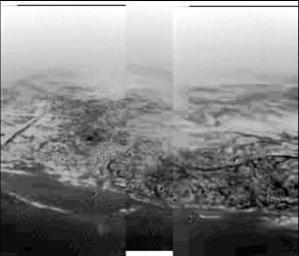
English: This composite was produced from images returned yesterday, January 14, 2005, by the European Space Agency's Huygens probe during its successful descent to land on Titan. It shows the boundary between the lighter-colored uplifted terrain, marked with what appear to be drainage channels, and darker lower areas. These images were taken from an altitude of about 8 kilometers (about 5 miles) and a resolution of about 20 meters (about 65 feet) per pixel. The images were taken by the Descent Imager/Spectral Radiometer, one of two NASA instruments on the probe.
Deutsch: Fotografie der Titanoberfläche während des Landeanflugs von Huygens. Man erkennt Hügel und topographische Merkmale, die einer Küstenregion mit Abflussgräben gleichen, 2005. |
| Дата | |
| Источник | http://photojournal.jpl.nasa.gov/catalog/PIA07231 (image link) |
| Автор | NASA/JPL/ESA/University of Arizona |
Это изображение или видеозапись внесены в каталог Лаборатории реактивного движения НАСА под идентификатором (Photo ID): PIA07231. Этот шаблон не указывает на правовой статус данной работы. По-прежнему необходим нормальный шаблон лицензий. См. Commons:Лицензирование. Другие языки:
|
Лицензирование
| Этот файл находится в общественном достоянии (англ. public domain), так как он был создан NASA (Национальным управлением по аэронавтике и исследованию космического пространства). Политика авторского права NASA гласит, что «Материал NASA не защищается авторским правом, если не указано иное». (См. Template:PD-USGov, страницу политики авторского права NASA или политику использования изображений JPL.) | ||
 |
Предупреждения:
|
Исходный журнал загрузок
(All user names refer to en.wikipedia)
- 2005-01-15 18:17 The Singing Badger 305×261×8 (25004 bytes) Descent image of Titan taken during Huygens' landing, showing an apparent shoreline with hills and drainage channels {{PD-USGov-NASA}}
История файла
Нажмите на дату/время, чтобы посмотреть файл, который был загружен в тот момент.
| Дата/время | Миниатюра | Размеры | Участник | Примечание | |
|---|---|---|---|---|---|
| текущий | 17:31, 14 ноября 2007 | | 305 × 261 (24 КБ) | File Upload Bot (Magnus Manske) | {{BotMoveToCommons|en.wikipedia}} {{Information |Description={{en|Image of Titan taken during Huygens' descent, showing hills and topographical features that resemble a shoreline and drainage channels Credit: [ |
Использование файла
Следующая страница использует этот файл:
Глобальное использование файла
Данный файл используется в следующих вики:
- Использование в als.wikipedia.org
- Использование в ar.wikipedia.org
- Использование в de.wikipedia.org
- Использование в en.wikipedia.org
- Использование в fr.wikipedia.org
- Использование в gl.wikipedia.org
- Использование в id.wikipedia.org
- Использование в io.wikipedia.org
- Использование в it.wikipedia.org
- Использование в ja.wikipedia.org
- Использование в lb.wikipedia.org
- Использование в nl.wikipedia.org
- Использование в no.wikipedia.org
- Использование в simple.wikipedia.org
- Использование в sr.wikipedia.org
- Использование в sv.wikipedia.org
- Использование в zh.wikipedia.org