Файл:Earth and Moon - GPN-2000-001437.jpg
Перейти к навигации
Перейти к поиску

Размер этого предпросмотра: 490 × 599 пкс. Другие разрешения: 196 × 240 пкс | 392 × 480 пкс | 628 × 768 пкс | 837 × 1024 пкс | 1696 × 2074 пкс.
Исходный файл (1696 × 2074 пкс, размер файла: 1,26 МБ, MIME-тип: image/jpeg)
Этот файл находится на Викискладе. Сведения о нём показаны ниже.
Викисклад — централизованное хранилище для свободных файлов, используемых в проектах Викимедиа.
|
Краткое описание
| Описание |
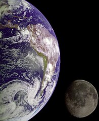
English: During its flight, the Galileo spacecraft returned images of the Earth and Moon. Separate images of the Earth and Moon were combined to generate this view. The Galileo spacecraft took the images in 1992 on its way to explore the Jupiter system in 1995-97. The image shows a partial view of the Earth centered on the Pacific Ocean about latitude 20 degrees south. The west coast of South America can be observed as well as the Caribbean; swirling white cloud patterns indicate storms in the southeast Pacific. The distinct bright ray crater at the bottom of the Moon is the Tycho impact basin. The lunar dark areas are lava rock filled impact basins. This picture contains same scale and relative color/albedo images of the Earth and Moon. False colors via use of the 1-micron filter as red, 727-nm filter as green, and violet filter as blue. The Galileo project is managed for NASA's Office of Space Science by the Jet Propulsion Laboratory. |
| Дата | |
| Источник | Great Images in NASA Description |
| Автор | NASA/JPL |
Это изображение или видеозапись внесены в каталог Лаборатории реактивного движения НАСА под идентификатором (Photo ID): GPN-2000-001437 и под альтернативным идентификатором: PIA00342. Этот шаблон не указывает на правовой статус данной работы. По-прежнему необходим нормальный шаблон лицензий. См. Commons:Лицензирование. Другие языки:
|
Лицензирование
| Этот файл находится в общественном достоянии (англ. public domain), так как он был создан NASA (Национальным управлением по аэронавтике и исследованию космического пространства). Политика авторского права NASA гласит, что «Материал NASA не защищается авторским правом, если не указано иное». (См. Template:PD-USGov, страницу политики авторского права NASA или политику использования изображений JPL.) | ||
 |
Предупреждения:
|
История файла
Нажмите на дату/время, чтобы посмотреть файл, который был загружен в тот момент.
| Дата/время | Миниатюра | Размеры | Участник | Примечание | |
|---|---|---|---|---|---|
| текущий | 01:07, 18 апреля 2015 | | 1696 × 2074 (1,26 МБ) | Jcpag2012 | same existing file (1 MB) - NASA image |
| 17:59, 24 апреля 2006 |  | 1696 × 2074 (1,26 МБ) | Uwe W. | Title The Earth and Moon Full Description During its flight, the Galileo spacecraft returned images of the Earth and Moon. Separate images of the Earth and Moon were combined to generate this view. The Galileo spacecraft took the images in 1992 on its way |
Использование файла
Следующая страница использует этот файл:
Глобальное использование файла
Данный файл используется в следующих вики:
- Использование в en.wikipedia.org
- Использование в es.wikipedia.org
- Использование в ms.wikipedia.org
- Использование в nl.wikibooks.org
- Использование в no.wikipedia.org
- Использование в ro.wiktionary.org
- Использование в sl.wikipedia.org
- Использование в th.wikipedia.org
- Использование в vls.wikipedia.org