Перейти на страницу файла на Викискладе

Файл:Central-eastern Brazil, by Copernicus Sentinel-2A satellite.jpg

Материал из Википедии — свободной энциклопедии
Перейти к навигации Перейти к поиску

Исходный файл(11 458 × 10 980 пкс, размер файла: 94,42 МБ, MIME-тип: image/jpeg)

Краткое описание

Внимание! Изображение содержит очень большое количество пикселей, и при просмотре его в полном разрешении в некоторых обозревателях могут возникнуть такие проблемы, как загрузка искажённого изображения или зависание.
Описание
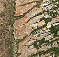
English: Central-eastern Brazil, by Copernicus Sentinel-2A satellite.

Here we can see a large, flat plateau blanked with fields benefiting from rich soils and an apparent abundance of water, before falling off into a green, hilly valley (left). The straight lines in the image are roads, such as the highway running in a nearly straight line from the centre-top to bottom of the image.

The area is particularly known for soybean production. The country’s soybean output has increased by more than 3000% since the 1970s, and Brazil is the second largest global producer of soybeans after the US.

Other crops in this area include corn, coffee and cotton.

A distinctive feature in this image is the circles – mainly at the centre. These shapes were created by a central-pivot irrigation system, where a long water pipe rotates around a well at the centre of each plot. The varying colours show different types of crop, or different stages of growth.

The two-satellite Sentinel-2 mission is designed to monitor changing lands, including crop type and health. While the first satellite has been in orbit since 2015, its Sentinel-2B twin was launched on 7 March. Together, the satellites will provide new images of Earth’s land surfaces every five days.
Дата
Источник http://www.esa.int/spaceinimages/Images/2017/04/Central-eastern_Brazil
Автор ESA / Copernicus Sentinel-2A

Featured изображение

Викисклад

Этот файл имеет статус избранного изображения (Избранные изображения) на Викискладе и в настоящее время признан там одним из лучших изображений.

Если у вас есть изображение аналогичного качества, которое может быть опубликовано под свободной лицензией, пожалуйста, загрузите его, выберите лицензию и номинируйте его.

Лицензирование

w:ru:Creative Commons
атрибуция распространение на тех же условиях
Этот файл доступен по лицензии Creative Commons Attribution-Share Alike 3.0 IGO.
Вы можете свободно:
  • делиться произведением – копировать, распространять и передавать данное произведение
  • создавать производные – переделывать данное произведение
При соблюдении следующих условий:
  • атрибуция – Вы должны указать авторство, предоставить ссылку на лицензию и указать, внёс ли автор какие-либо изменения. Это можно сделать любым разумным способом, но не создавая впечатление, что лицензиат поддерживает вас или использование вами данного произведения.
  • распространение на тех же условиях – Если вы изменяете, преобразуете или создаёте иное произведение на основе данного, то обязаны использовать лицензию исходного произведения или лицензию, совместимую с исходной.
Этот файл, изначально опубликованный на внешнем сайте http://www.esa.int/spaceinimages/Images/2017/04/Central-eastern_Brazil, был проверен 6 мая 2017 проверяющим Daphne Lantier, подтвердившим, что файл был там доступен в ту дату на условиях указанной лицензии.
© This image contains data from a satellite in the Copernicus Programme, such as Sentinel-1, Sentinel-2 or Sentinel-3. Attribution is required when using this image.
Атрибуция: Contains modified Copernicus Sentinel data 2016

The use of Copernicus Sentinel Data is regulated under EU law (Commission Delegated Regulation (EU) No 1159/2013 and Regulation (EU) No 377/2014). Relevant excerpts:


Financial conditions

Free access shall be given to GMES dedicated data [...] made available through GMES dissemination platforms [...].

Conditions regarding use

Access to GMES dedicated data [...] shall be given for the purpose of the following use in so far as it is lawful:

  1. reproduction;
  2. distribution;
  3. communication to the public;
  4. adaptation, modification and combination with other data and information;
  5. any combination of points (a) to (d).

GMES dedicated data [...] may be used worldwide without limitations in time.

Conditions regarding information to be given by users
  1. When distributing or communicating GMES dedicated data [...] to the public, users shall inform the public of the source of that data and information.
  2. Users shall make sure not to convey the impression to the public that the user’s activities are officially endorsed by the Union.
  3. Where that data or information has been adapted or modified, the user shall clearly state this.
Absence of warranty

GMES dedicated data and GMES service information are provided to users without any express or implied warranty, including as regards quality and suitability for any purpose.

Краткие подписи

Добавьте однострочное описание того, что собой представляет этот файл

Элементы, изображённые на этом файле

изображённый объект

image/jpeg

99 007 576 байт

10 980 пиксель

11 458 пиксель

История файла

Нажмите на дату/время, чтобы посмотреть файл, который был загружен в тот момент.

Дата/времяМиниатюраРазмерыУчастникПримечание
текущий10:45, 12 июня 2020Миниатюра для версии от 10:45, 12 июня 202011 458 × 10 980 (94,42 МБ)The RedBurnColor balance
22:03, 5 мая 2017Миниатюра для версии от 22:03, 5 мая 201711 458 × 10 980 (92,43 МБ)Yannc:User:Rillke/bigChunkedUpload.js: HR from TIFF, 98% compression
20:24, 5 мая 2017Миниатюра для версии от 20:24, 5 мая 20171920 × 1840 (3,84 МБ)YannTransferred from http://www.esa.int/var/esa/storage/images/esa_multimedia/images/2017/04/central-eastern_brazil/16900171-1-eng-GB/Central-eastern_Brazil.jpg

Следующая страница использует этот файл:

Глобальное использование файла

Данный файл используется в следующих вики:

Метаданные